Haji Malang Gad, also known as Shree Malanggad, is a fort located at a height of 3200 ft above sea level, near Kalyan in Maharashtra. It derives its name after a Sufi saint Hazrat Haji Malang Baba who is believed to have spent his life on this hill. His holy shrine - Haji Malang Dargah is a pilgrimage for people from diverse beliefs and faiths who visit the dargah every year. Known for its religious significance, Malanggad fort also has an elaborate history of the Maratha-British war of the 18th century, a captivating view of the district from the hilltop, and a well-designed fort structure which makes it a perfect trek destination to explore.
The trek is best suited for both amateurs as well as experienced trekkers looking for an enthralling adventure as the trek is divided into three difficulty levels - easy, moderate, and difficult.
 |
| Malanggad fort Kalyan |
Easy Part of the Trek –Visiting Haji Malang Dargah
Haji Malang Dargah situated at the lowest plateau of Malang Gad is the easy part of the trek. The route from the base village to the dargah consists of 1500 concrete steps. It takes about 2-2.5 hours from the starting point depending on whether the route is crowded with the devotees. The concrete steps covered with a shade for most of the part and numerous shops providing refreshments make it less of a trek and more of a tourist destination that can be easily covered by everyone.
 |
| Concrete steps leading to Haji Malang Dargah |
The major stops are Pehli Salami, Doosri Salami, and the main Haji Malang Dargah. After a further climb, you can visit Panch Pir Dargah at the Pir Machi. There are also many Hindu temples along the way.
 |
| Haji Malang Baba Dargah |
 |
| Pilgrims climbing down the mountain of Malanggad |
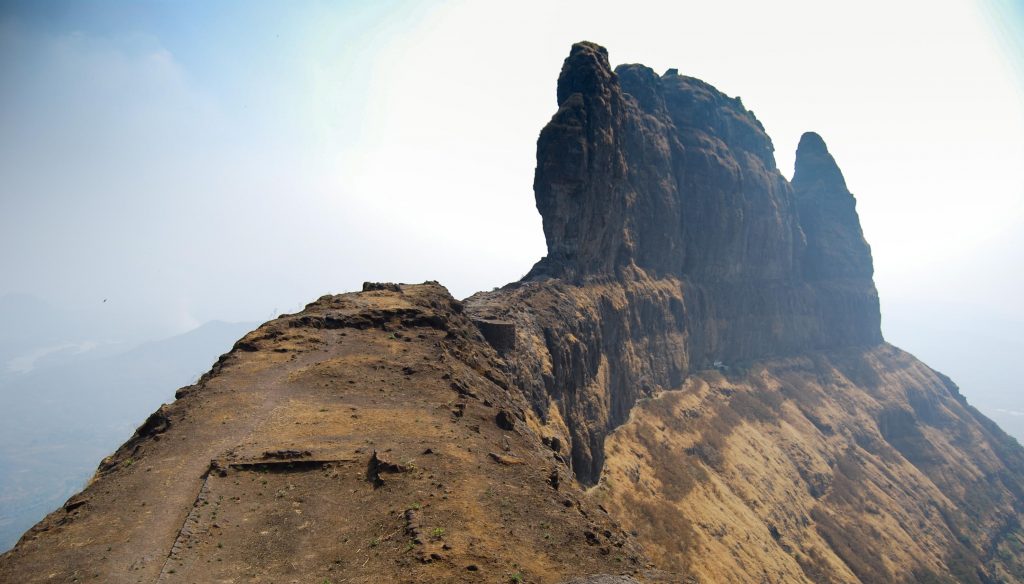
Moderate part of the trek – Visiting Sone Machi
Those seeking a spectacular trek experience after visiting the holy shrine can continue climbing the mountain and head towards the main fort. Sone Machi, which resembles an elephant's trunk, is a long plateau measuring 25 meters wide and 250 meters long, with a 70-foot-wide and 100-foot-tall rock projection at one end. The route towards Sone Machi consists of narrow steps cut between rocks and boulders and can be rated as a moderate difficulty level. Although it could get a bit exhaustive for beginners, it is fairly easy for experienced trekkers.
 |
| Steps leading to the Malanggad fort |
Once you reach the Sone Machi, all the tiring journey becomes worth it for the breathtaking view of the hills and valleys around.
 |
| Plateau of Sone Machi – imposing citadel summit |
Difficult part of the trek –Visiting Balekilla
After enjoying the spectacular landscape at Sone Machi, the real challenge lies ahead as you approach Balekilla(citadel), the trek's highest, difficult, and final destination. The citadel is 200 yards long and 70 yards tall. However, getting there requires crossing a 14-foot gap connected by a narrow pipe. Crossing this path without a safety belt and rope is extremely dangerous. The climb is very steep and involves high risk. Hence it is not advisable to ascend the pinnacle without a safety harness and experienced guide to ensure safety.
 |
| Stone structure built at Balekilla |
 |
| Balekilla pipe crossing |
 |
| Steep climb to reach Balekilla |
 |
| Risky pipe crossing with the rope support |
In a nutshell, Haji Malang Gad trek can be divided into three levels of difficulty-easy, medium, difficult making it a suitable trek destination for beginners as well as experienced. However, it is important to take necessary precautions while attempting to trek the higher levels.
Want to plan a trek soon? Read our travel guide of Haji Malang Gad trek for detailed information.